https://decibel.ni.com/content/docs/DOC-2117
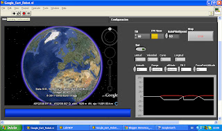
This is the image of the interface:
The interface displays me the latitude, longitude, speed, course,and I graph the angles from accelerated uns meters and degreesfrom an electronic compass, they are sent by RS232 from a megaarduino, which is responsible for capturing data from the GPS andcompass.
The GPS 50 Channel GPS Receiver Helical D2523T
The GPS 50 Channel GPS Receiver Helical D2523T
the compass is CMPS09
All this is hooked to a robotics platform, which you can browse forwireless communication with the help of the GPS and the user will see on google earth the location of the robot, is now working withXBee of 1500 Mts to line of sight, but future this will be replaced bymore powerful radio modem.


No hay comentarios:
Publicar un comentario